Olympic Mountain Glory
 NASAJuly 23, 20265 min read1 views
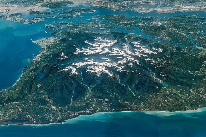
Earth Observatory Science Earth Observatory Olympic Mountain Glory Earth Earth Observatory Image of the Day EO Explorer Topics All Topics Atmosphere Land Heat & Radiation Life on Earth Human Dimensions Natural Events Oceans Remote Sensing Technology Snow & Ice Water More Content Collections Global Maps World of Change Articles Earth Matters Blog Blue Marble: Next Generation EO Kids Mission: Biomes About About Us Subscribe 🛜 RSS Contact Us Search May 6, 2016 Alpine glaciers, wild coastlines, temperate rainforests, and deep river valleys coexist on the Olympic Peninsula in the northwest corner of Washington state. Surrounded by blue waters, peaceful islands, and bustling population centers, its rugged interior remains a relatively remote bastion of wilderness. The Olympic Mountains’ imposing terrain comes into focus in this oblique view of the region, captured by an astronaut aboard the International Space Station.
The image is a composite , made of several sequential, overlapping photos fused together into a panorama. Olympic National Park encompasses the peninsula’s mountainous core, along with some stretches of the Pacific coastline. Much of the remaining area is either national forest, state-owned land, or tribal territory.
The rock making up the mountains mostly originated beneath the surface of the ocean. From about 55 to 15 million years ago , layers of basalt from undersea eruptions and sand and mud transported seaward by rivers accumulated on the ocean bottom. This material was scraped off the Juan de Fuca plate as it subducted beneath the North American plate, with rock layers crumpling and rising up to 8,000 feet (2,440 meters) above sea level.
Tectonic forces continue to push the mountains skyward, but the countervailing force of erosion in this rainy, snowy corner of the country effectively cancels out the uplift. Snow at higher elevations feeds glaciers that carve out underlying rock. Glaciers in the Olympics are retreating and thinning, however, and their numbers are declining.
One study tallied 255 glaciers and perennial snowfields in the range in 2015 and found that 35 glaciers and 16 perennial snowfields had disappeared in the preceding 35 years. Other erosion is evidenced by the deep valleys radiating out from the snowy peaks. The Hoh, Queets, and Quinault rivers, draining west into the Pacific Ocean (bottom of the frame), are prominent in this view.
, uninterrupted by human-caused noise. Flowing to the north, the Elwha River has a rich natural and human history, including some of the earliest Euro-American exploration of the Olympics. Sponsored by a Seattle newspaper, an expedition from December 1889 to May 1890 crossed the mountain range from north to south, traveling up the Elwha valley and down the Quinault.
NASA
nasa.gov